
Persian Gulf
West Asia
Persian Gulf: Ship attacks prompt maritime high-alert directive
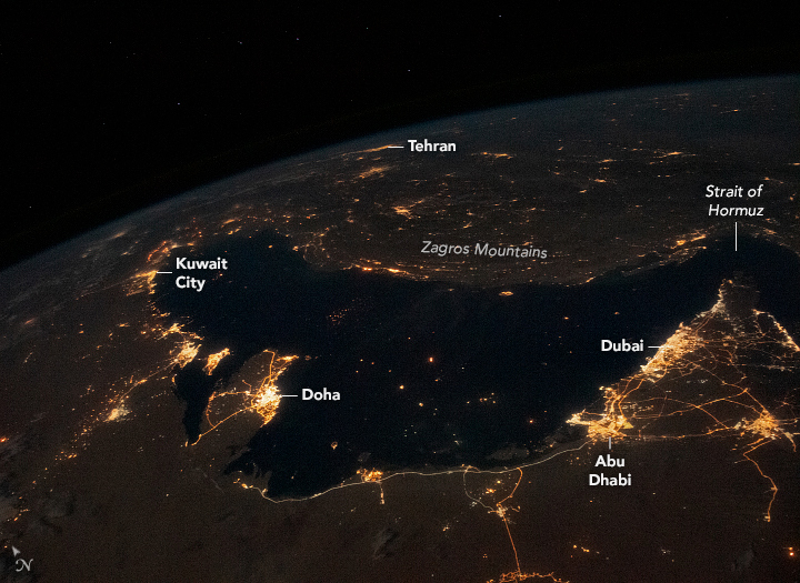
The Persian Gulf is a shallow, semi-enclosed arm of the Indian Ocean between Iran and the Arabian Peninsula. It connects to the Gulf of Oman through the Strait of Hormuz.
Approximate location — this pin marks the general area, not an exact surveyed point. Other numbered pins are the day's other places.
Why in the news
Ship attacks in the Persian Gulf raised maritime security concerns. Shipping Minister Sarbananda Sonowal asked India's maritime regulator to remain on high alert in high-risk areas.
Water-body type
Semi-enclosed gulf
Ocean system
Indian Ocean
Outlet
Strait of Hormuz
Connected water body
Gulf of Oman
Major river inflow
Shatt al-Arab
Location
- Lies between Iran to the north and east and the Arabian Peninsula to the south and west.
- Extends southeastwards from the coasts of Iraq and Kuwait towards the Strait of Hormuz.
- Connects through the Strait of Hormuz to the Gulf of Oman and, beyond it, the Arabian Sea.
- Receives the Shatt al-Arab river at its northwestern end.
Coastal countries
- Iran
- Iraq
- Kuwait
- Saudi Arabia
- Bahrain
- Qatar
- United Arab Emirates
- Oman
Key features
- Shallow marine basin
- A shallow continental-shelf sea, generally deeper near the Iranian side than along the Arabian coast.
- Strait of Hormuz
- Its narrow southeastern outlet is a major maritime chokepoint between Iran and Oman's Musandam Peninsula.
- Shatt al-Arab
- Formed by the confluence of the Tigris and Euphrates, this river enters the head of the gulf.
- Peninsulas and islands
- Qatar projects into the gulf, while Bahrain is an island country off the eastern coast of Saudi Arabia.
- Hydrocarbon basin
- The gulf and its surrounding sedimentary basins contain major petroleum and natural gas resources.
Flora, fauna & ecology
- Arid setting
- High evaporation and limited freshwater input contribute to high salinity.
- Coastal habitats
- Coral reefs, seagrass beds, mangroves and intertidal flats occur along parts of the coast.
- Marine fauna
- Seagrass habitats support dugongs, while marine turtles also inhabit the gulf.
History & significance
- Pearl diving and maritime trade were important coastal livelihoods before the expansion of the petroleum economy.
UPSC angle
- Prelims map work: distinguish the Persian Gulf, Gulf of Oman, Arabian Sea and Strait of Hormuz.
- Physical geography: examine salinity in semi-enclosed seas and the influence of evaporation and river inflow.
- GS II and GS III: link West Asian maritime security with India's energy security and sea lines of communication.
- Environment: locate vulnerable coral, seagrass and mangrove ecosystems in an arid coastal setting.
Also locate on your map
- Strait of Hormuz
- Gulf of Oman
- Arabian Sea
- Musandam Peninsula
- Shatt al-Arab
- Qatar Peninsula
- Bahrain
- Qeshm Island
Test yourself
Q1. Which of the following correctly traces the sea route from the Persian Gulf towards the open Indian Ocean?
Q2. The Shatt al-Arab, which enters the northwestern Persian Gulf, is formed by the confluence of which rivers?
Sources
Background maps and imagery © Esri and partners (English labels); place positions checked with OpenStreetMap (ODbL). Boundaries are for study reference only. Prepared by Pragnya IAS Academy for exam revision.