
Cyclone Arnab: Landfall, Early Warning and Coastal Disaster Preparedness
Revise the static topic: UPSC Geography notes · UPSC Disaster Management notes
In short: According to the supplied reports, Cyclone Arnab’s landfall process began along the Andhra Pradesh coast early on October 28, 2026, bringing destructive winds, heavy rainfall and a threat of coastal inundation. The emergency highlights that accurate forecasts must translate into timely evacuation, safe shelters, resilient lifelines and coordinated action across coastal and inland districts.
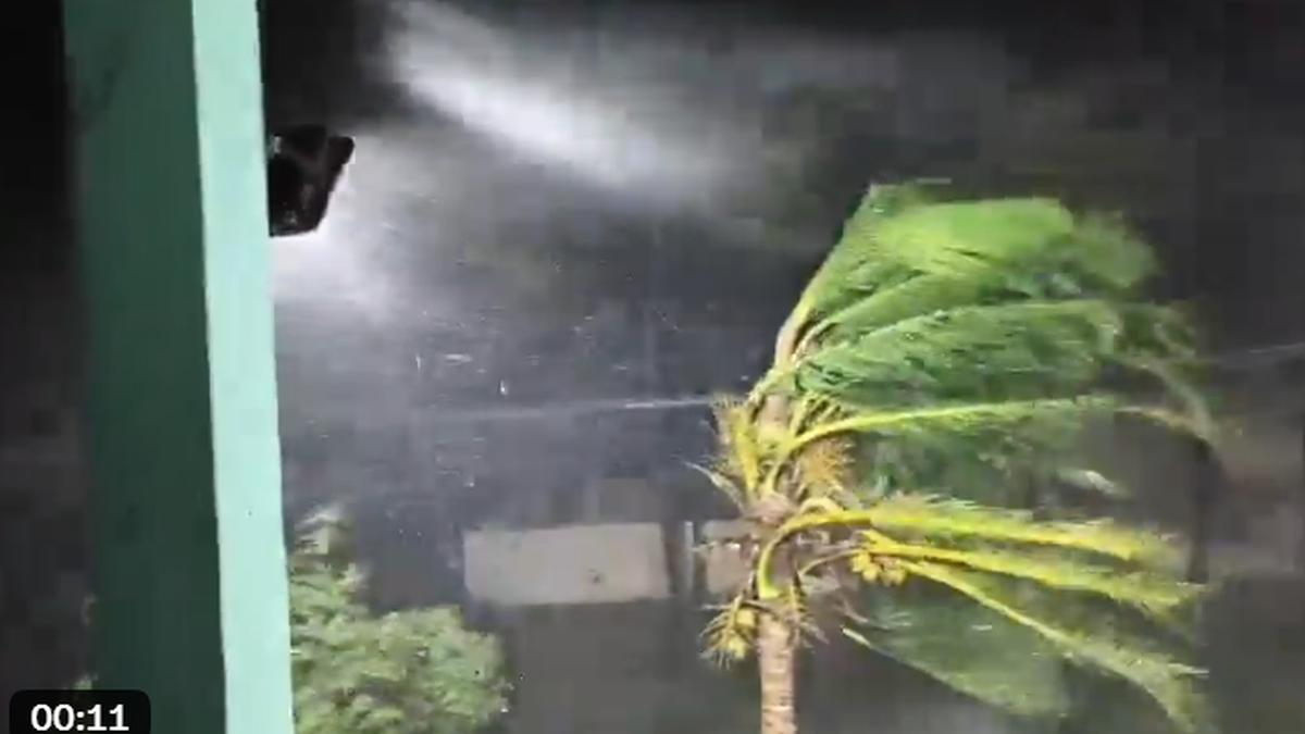
Photo from the source report: Cyclone Arnab: Landfall, Early Warning and Coastal Disaster Preparedness
Image: The Hindu
Why in news
The Hindu’s reports, citing IMD, described Arnab’s landfall process as continuing, with winds of 125–135 kmph near the centre and a forecast storm surge over Kakinada and Yanam. Andhra Pradesh and Odisha activated evacuation, transport restrictions and emergency response arrangements.
125–135 kmph
Reported winds near cyclone centre
1.5–2.5 m
Forecast surge over Kakinada–Yanam
84,396
People reportedly evacuated in Andhra Pradesh
290
Cyclone shelters reportedly set up in Andhra Pradesh
More than 30,000
Fishing boats reportedly brought back from sea
231.5 mm
Kannuripalem rainfall in the reported observation period
Background
Tropical cyclones are organised low-pressure systems that develop over warm tropical oceans and draw energy from moist air and the release of latent heat during condensation. India’s eastern coast faces the Bay of Bengal, where coastal lowlands, river deltas, settlements and fishing infrastructure are exposed to cyclone winds, heavy rain and seawater inundation. Andhra Pradesh’s coast and Yanam, an enclave of the Union Territory of Puducherry, illustrate the need for coordination across administrative boundaries. India’s disaster management framework connects national guidance and specialised response with State-level coordination, district administration and local implementation.
What the reports establish—and what remains provisional
The supplied reports describe the beginning of Arnab’s landfall process along the Andhra Pradesh coast early on October 28. One report places the beginning near Narsapur, while other updates refer to the coast south of Yanam and the wider Bapatla–Visakhapatnam stretch. IMD experts quoted in the reports cautioned that the exact crossing location could not yet be firmly identified.
Landfall technically refers to the cyclone’s centre crossing the coastline. Operational updates may describe a broader landfall process as rainbands and the core move ashore; damaging weather can therefore precede the centre’s crossing and extend far beyond it.
The reports predominantly describe Arnab as a very severe cyclonic storm. Because the live feed contains varying descriptions and evolving forecasts, its reported category and wind estimates should be treated as time-specific information, not as a final post-event assessment.
- Reported winds near the centre were 125–135 kmph, gusting to 150 kmph.
- A storm surge of 1.5–2.5 m was forecast over Kakinada and Yanam; this was not a confirmed measurement of inundation.
- Kannuripalem recorded 231.5 mm of rain between the morning of October 27 and early October 28.
- Evacuation figures, rainfall observations and damage reports represent different reporting times and should not be treated as final totals.
Infographic
Understand the hazards
Assess wind, rain, surge and cascading failures together.
Warn for action
Deliver local, accessible and impact-based instructions.
Evacuate inclusively
Provide transport, safe shelters and trusted community support.
Protect lifelines
Keep healthcare, power, communications and access functional.
Coordinate and recover
Share operational information and rebuild with lower risk.
AI-assisted infographic by Pragnya IAS Academy, based on the cited sources.
How tropical cyclones form and intensify
Cyclogenesis requires a favourable combination of warm ocean water, moisture, a pre-existing atmospheric disturbance, sufficient Coriolis force and weak vertical wind shear. Warm, moist air rises within a disturbance; condensation releases latent heat, supporting convection and helping sustain the low-pressure circulation.
Surface air converges towards the low-pressure centre and is deflected by the Coriolis force, producing an anticlockwise circulation in the Northern Hemisphere. Weak vertical wind shear helps the circulation remain vertically organised, while upper-level outflow allows rising air to spread outward.
In a well-developed cyclone, the strongest winds commonly occur in the eyewall surrounding the relatively calmer eye. After landfall, reduced oceanic heat and moisture supply and increased surface friction generally weaken the circulation, but heavy rain and flooding can continue inland.
- Warm water alone does not guarantee cyclone formation; atmospheric conditions must also be favourable.
- Cyclones rarely form very close to the equator because the Coriolis force is weak.
- Vertical wind shear means a change in wind speed or direction with height.
- A temporary lull is not proof that the cyclone has passed and should never substitute for an official all-clear.
Why cyclone risk is a compound-hazard problem
Arnab’s reported impacts show that wind speed alone cannot capture disaster risk. Strong winds damage roofs, trees, boats and electricity networks; intense rain overwhelms drainage and floods settlements; storm surge raises coastal water levels and threatens low-lying areas. Their interaction can obstruct evacuation and emergency access.
The reported death involving a fallen live wire in water illustrates a cascading hazard: wind damage to electricity infrastructure can turn waterlogged streets into electrocution zones. Rainfall threats in southern Odisha also show why preparedness cannot be confined to the immediate landfall coast.
- Storm surge is an abnormal rise of seawater above the predicted astronomical tide; it is not synonymous with a large individual wave.
- Coastal flooding depends on surge, tide, waves, coastal elevation and local drainage conditions.
- Heavy rain can produce river flooding, urban waterlogging and landslips in susceptible hill terrain.
- Damage to roads, power and telecommunications can delay rescue, healthcare and essential supplies.
- Loss of boats, nets, crops and housing can prolong livelihood distress after the immediate emergency ends.
Early warning and evacuation: converting forecasts into protection
The reports indicate that the expected crossing time shifted earlier as the cyclone approached. This makes continuous updating essential: warnings must identify the threatened locations, likely impacts, protective action and the time available for action, rather than merely repeat the storm’s category.
Andhra Pradesh reported large-scale evacuation, shelter activation and the return of fishing boats. However, officials in Yanam reported reluctance among residents to leave their homes despite repeated warnings. This reveals a last-mile challenge: receiving a warning does not automatically mean trusting it or acting upon it.
Evacuation becomes more acceptable when people have accessible transport, safe shelters, reliable information and confidence that their property and livelihoods will not be abandoned. The reported safety of evacuated residents whose thatched houses collapsed in Uppada illustrates the protective value of moving before destructive conditions arrive.
- Use local-language, location-specific messages through phones, radio, public-address systems and door-to-door outreach.
- Prioritise older persons, persons with disabilities, pregnant women, children and households without transport.
- Provide drinking water, sanitation, essential medicines, privacy and accessible facilities in shelters.
- Address concerns about theft, livestock and fishing assets through locally credible arrangements.
- Do not interpret a period of calm sea or reduced rainfall as evidence that evacuation is unnecessary.
Disaster governance and resilient lifelines
Under the Disaster Management Act, national, State and district institutions have complementary responsibilities. NDMA provides national policy and guidelines; State authorities coordinate planning and preparedness; district administrations and local bodies organise evacuation, shelter management and local response. IMD supplies meteorological monitoring and warnings, while the National Disaster Response Force provides specialised response support.
The reported mobilisation of electricity personnel, disaster response teams, the Navy and the Coast Guard, alongside aviation and railway restrictions, demonstrates the breadth of cyclone management. Effective coordination requires a shared operational picture, clear task allocation and consistent public communication—not merely the presence of multiple agencies.
Resilience must extend beyond emergency shelters. Safer housing, protected power and communication systems, functioning drainage, reliable evacuation routes and continuity plans for hospitals reduce cascading losses. Mangroves and other coastal ecosystems can complement engineered protection but cannot replace evacuation or withstand every level of hazard.
- Coordinate Andhra Pradesh, Puducherry’s Yanam administration and neighbouring Odisha through shared alerts and resource information.
- Identify critical facilities requiring backup electricity, communications and assured emergency access.
- Sequence restoration so that electrical safety and structural inspection precede public re-entry.
- Integrate ecosystem conservation, risk-sensitive land use and cyclone-resistant construction.
- Use recovery to reduce future exposure rather than recreate damaged assets with the same vulnerabilities.
| Hazard | Risk pathway | Preparedness priority |
|---|---|---|
| Destructive winds | Roof damage, falling trees and electricity-line failure | Strengthen structures, manage roadside trees and isolate unsafe electrical networks |
| Storm surge | Seawater inundation of low-lying coastal settlements | Use inundation maps and evacuate exposed populations before access deteriorates |
| Intense rainfall | Urban flooding, river flooding and drainage congestion | Clear drains, monitor water levels and keep rescue access available |
| Rain-triggered landslips | Slope failure and blocked hill roads | Restrict unsafe routes and relocate people from identified vulnerable sites |
| Rough seas and high waves | Danger to fishers, boats and shoreline infrastructure | Suspend unsafe marine activity and secure fishing assets where feasible |
| Lifeline disruption | Interrupted healthcare, communications, electricity and transport | Provide redundancy, backup supplies and prioritised restoration |
- 1. IMD monitors the cyclone and updates track, intensity and associated weather forecasts.
- 2. Authorities combine forecasts with local exposure and vulnerability maps.
- 3. Impact-based warnings specify threatened locations, likely consequences and required action.
- 4. District teams and community volunteers arrange evacuation, transport and shelter support.
- 5. Response agencies protect lifelines, conduct rescue and maintain essential services.
- 6. Authorities issue area-specific re-entry advice after safety checks and begin resilient recovery.
October 27, 2026
Heavy rain and strong winds affected Andhra Pradesh; evacuations, shelter activation, fishing-boat returns and transport restrictions were reported.
Early October 28, 2026
Reports citing IMD said Arnab’s landfall process had begun along the Andhra Pradesh coast; the exact crossing location remained provisional.
October 28, 2026, subsequent live updates
IMD was reported as saying that the centre remained close to the coastline and the landfall process was continuing.
Significance, challenges & way forward
Significance
- The event demonstrates that cyclone preparedness must address wind, rain, surge and cascading infrastructure failures together.
- Early evacuation can protect lives even where fragile housing and coastal assets suffer severe damage.
- Yanam’s administrative geography makes cross-jurisdictional coordination central to effective coastal preparedness.
- Rainfall risks in inland and hill districts require a wider response footprint than the immediate landfall zone.
- Protection of fishing assets and essential services links disaster management with livelihood security and development.
Challenges
- Changes in the expected crossing time can compress evacuation and operational decision-making windows.
- Reluctance to leave homes can persist despite warnings when residents fear theft, asset loss or poor shelter conditions.
- Floodwater, fallen trees and damaged power lines can simultaneously block access and create secondary hazards.
- Forecast uncertainty can be misunderstood as institutional failure unless updates explain what has changed and why.
- Fragmented agency communication can generate inconsistent instructions and delay resource deployment.
- Initial reports do not establish the final landfall point, overall losses or the effectiveness of the complete response.
Way forward
- Issue impact-based, local-language warnings that connect each hazard with a clear protective action.
- Link evacuation triggers to likely inundation and route accessibility rather than waiting for the centre to cross the coast.
- Maintain inclusive evacuation registers and test transport and shelter arrangements through community drills.
- Establish shared operational information across State, Union Territory, district and sectoral agencies.
- Audit hospitals, shelters, electricity networks and communications for cyclone exposure and service continuity.
- Combine coastal ecosystem protection with risk-sensitive land use, safer housing and engineered infrastructure.
- Conduct post-event reviews of warning reach, evacuation barriers, infrastructure failures and livelihood recovery.
Key terms
- Cyclogenesis
- The development or strengthening of a cyclonic atmospheric circulation.
- Latent heat
- Energy released when water vapour condenses, helping sustain convection within tropical cyclones.
- Coriolis force
- The apparent deflection associated with Earth’s rotation that helps organise cyclonic circulation.
- Vertical wind shear
- A change in wind speed or direction with height that can disrupt a tropical cyclone’s vertical organisation.
- Landfall
- The crossing of a coastline by the centre of a tropical cyclone.
- Storm surge
- An abnormal rise in sea level caused by a storm, above the predicted astronomical tide.
- Impact-based warning
- A warning that explains likely consequences for people, assets and services rather than weather conditions alone.
- Cascading disaster risk
- Risk arising when an initial hazard triggers further failures, such as storm damage causing power outages and healthcare disruption.
Link with static syllabus
Prelims practice MCQs
Q1. With reference to tropical cyclone formation, consider the following statements: 1. Warm ocean water and abundant moisture support deep convection. 2. Strong vertical wind shear generally favours a vertically organised tropical cyclone. 3. The Coriolis force helps organise the rotating circulation. Which of the statements given above are correct?
Q2. Consider the following statements about cyclone hazards: 1. Storm surge is synonymous with the height of an individual wind-generated wave. 2. Damaging weather can occur before the cyclone’s centre crosses the coast. 3. A reduction in wind intensity after landfall necessarily ends the flood threat. Which of the statements given above is/are correct?
Q3. Consider the following pairs: 1. India Meteorological Department — Cyclone monitoring and meteorological warnings 2. National Disaster Response Force — Specialised disaster response 3. District administration — Local evacuation and shelter coordination Which of the pairs given above are correctly matched?
Q4. With reference to the geography relevant to Cyclone Arnab, consider the following statements: 1. Yanam is part of the Union Territory of Puducherry. 2. Andhra Pradesh’s coastline faces the Arabian Sea. 3. Cyclone-related rainfall can threaten inland hill districts as well as coastal districts. Which of the statements given above are correct?
Mains practice questions
GS 3 · 15 marks · 250 words
Accurate cyclone forecasts are necessary but insufficient for disaster risk reduction. Discuss with reference to early warning, evacuation, resilient infrastructure and inter-agency coordination.
Frequently asked questions
Where did Cyclone Arnab make landfall?
The supplied reports place the ongoing landfall process along the Andhra Pradesh coast, including a report of its beginning near Narsapur. They also quote IMD experts cautioning that the exact crossing location was not yet firmly established.
How is storm surge different from heavy-rain flooding?
Storm surge is an abnormal rise in coastal seawater associated with a storm, whereas heavy-rain flooding results from rainfall exceeding drainage or river-channel capacity. Both can occur together and worsen coastal inundation.
Why can an accurate warning fail to produce evacuation?
People may lack transport or distrust shelters, fear theft and livelihood losses, or underestimate danger during temporary calm. Effective evacuation therefore requires practical support and trusted local communication.
Does a cyclone becoming weaker after landfall mean the danger is over?
No. Heavy rain, inland flooding, unstable structures, fallen electrical lines and blocked roads can remain dangerous after winds weaken.
Sources
- The Hindu: Cyclone Arnab's landfall process continues along Andhra coast | LIVE
- The Hindu: Very severe cyclonic storm ‘Arnab’ begins landfall near Narsapur; Vizag battered by rain
- The Hindu: Cyclone Arnab: Flights, trains cancelled as heavy showers batters Andhra Pradesh; southern Odisha on edge
- The Hindu: Cyclone Arnab: Civil Aviation Ministry reviews situation to ensure safety of flight operations
Analysis prepared by the Pragnya IAS Academy current-affairs desk with AI assistance from the cited reports. Verify figures with the original sources.
Turn current affairs into marks
Join Pragnya IAS Academy's mentorship for daily answer-writing evaluation on stories like this — classroom programmes from a trusted name in IAS coaching in Hyderabad.