
Strait of Hormuz
Iran–Oman maritime passage, West Asia
Strait of Hormuz: Shipping threats raise global energy-security concerns
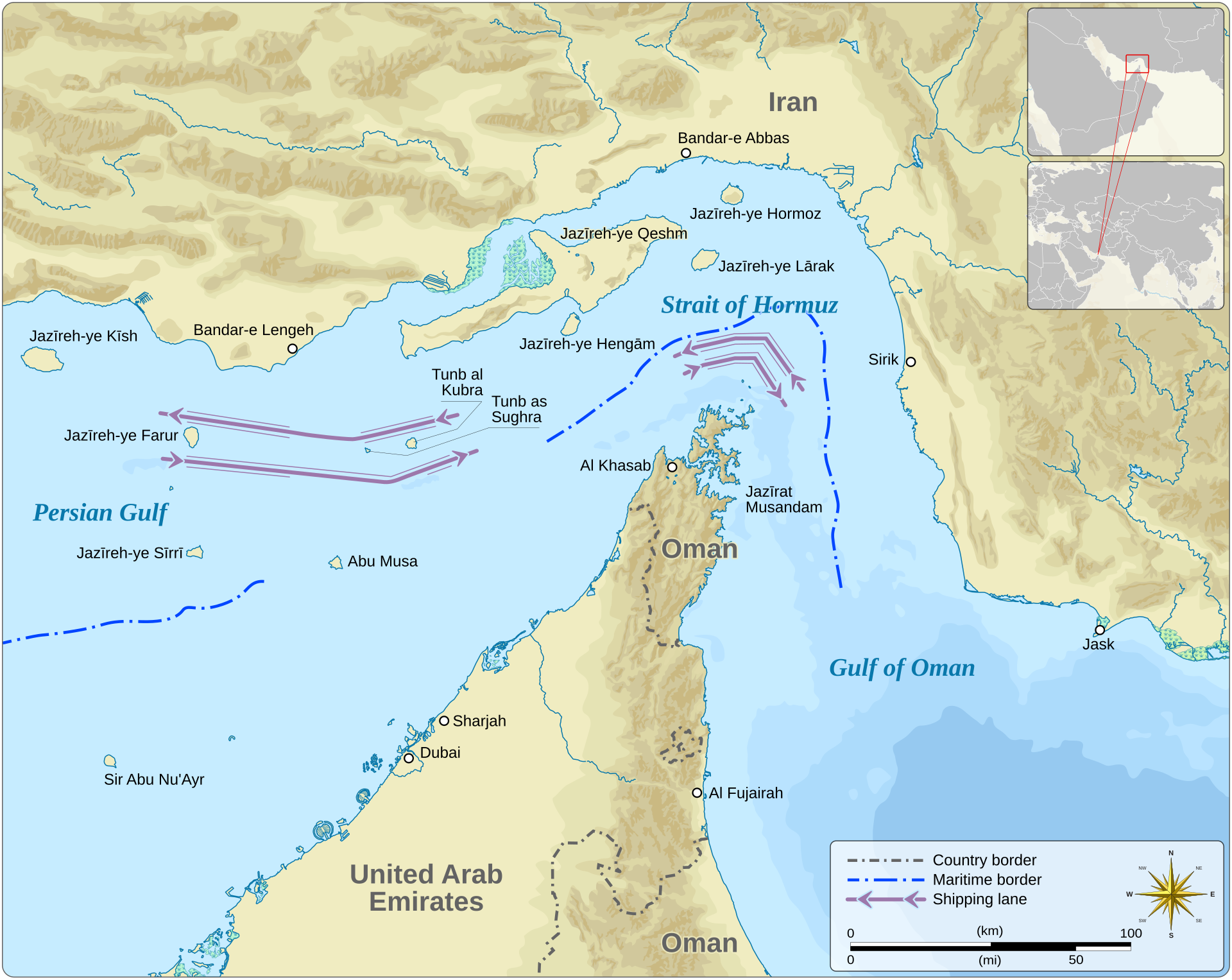
The Strait of Hormuz is a narrow maritime passage between Iran and Oman, connecting the Persian Gulf with the Gulf of Oman. It is a critical chokepoint for international energy shipments.
Position matched with OpenStreetMap; the dashed outline shows its mapped extent. Other numbered pins are the day's other places — tap one to open it.
Why in the news
Attacks on shipping and Iran’s reported near-closure of the strait prompted a UN Security Council meeting at Bahrain’s request. Threats to navigation have raised concerns over Gulf stability and global energy security.
Read the full analysis: Hormuz Shipping Crisis: UN Security Council Debate and India’s Energy RisksFeature type
Strait
Northern littoral state
Iran
Southern littoral state
Oman
Connected water bodies
Persian Gulf and Gulf of Oman
Key peninsula
Musandam
Ocean system
Indian Ocean
Location
- Lies between Iran to the north and Oman’s Musandam Peninsula to the south.
- Connects the Persian Gulf on its western side with the Gulf of Oman to the east.
- Provides the Persian Gulf’s maritime outlet towards the Arabian Sea and the wider Indian Ocean.
- Oman’s Musandam territory is separated from the rest of Oman by the United Arab Emirates.
Bordering countries
- Iran
- Oman
Key features
- Inter-gulf connection
- Forms the narrow passage linking the Persian Gulf and the Gulf of Oman.
- Musandam Peninsula
- Its mountainous headland projects into the strait from the southern side.
- Islands
- Qeshm, Hormuz and Larak lie near the Iranian side and the strait’s approaches.
- Maritime chokepoint
- Concentrates shipping entering and leaving the Persian Gulf into a restricted passage.
- Coastal relief
- Musandam has steep rocky shores and deeply indented inlets, locally called khors.
Flora, fauna & ecology
- Coastal climate
- The surrounding shores have a predominantly hot, arid climate.
- Marine habitats
- Coral communities occur around Musandam, while mangrove habitats occur around Qeshm.
UPSC angle
- Physical geography: locate the strait and distinguish the Persian Gulf, Gulf of Oman and Arabian Sea.
- Map-based questions: identify Iran and Oman as the bordering countries and locate Oman’s detached Musandam territory.
- Economic geography: examine maritime chokepoints, energy supply chains and India’s exposure to Gulf shipping disruptions.
- International relations: link freedom of navigation, regional security and the UN Security Council’s role.
Also locate on your map
- Persian Gulf
- Gulf of Oman
- Arabian Sea
- Musandam Peninsula
- Qeshm Island
- Bandar Abbas
- Bab el-Mandeb Strait
Test yourself
Q1. The Strait of Hormuz directly connects which of the following water bodies?
Q2. Consider the following statements about the Strait of Hormuz: 1. Iran lies along its northern side. 2. Oman’s Musandam Peninsula forms its southern side. 3. Musandam is separated from the rest of Oman by the United Arab Emirates. Which of the statements given above are correct?
Sources
Background maps and imagery © Esri and partners (English labels); place positions checked with OpenStreetMap (ODbL). Boundaries are for study reference only. Prepared by Pragnya IAS Academy for exam revision.