
Iran
West Asia
Iran: Nuclear talks stalled over enrichment; IAEA inspections barred
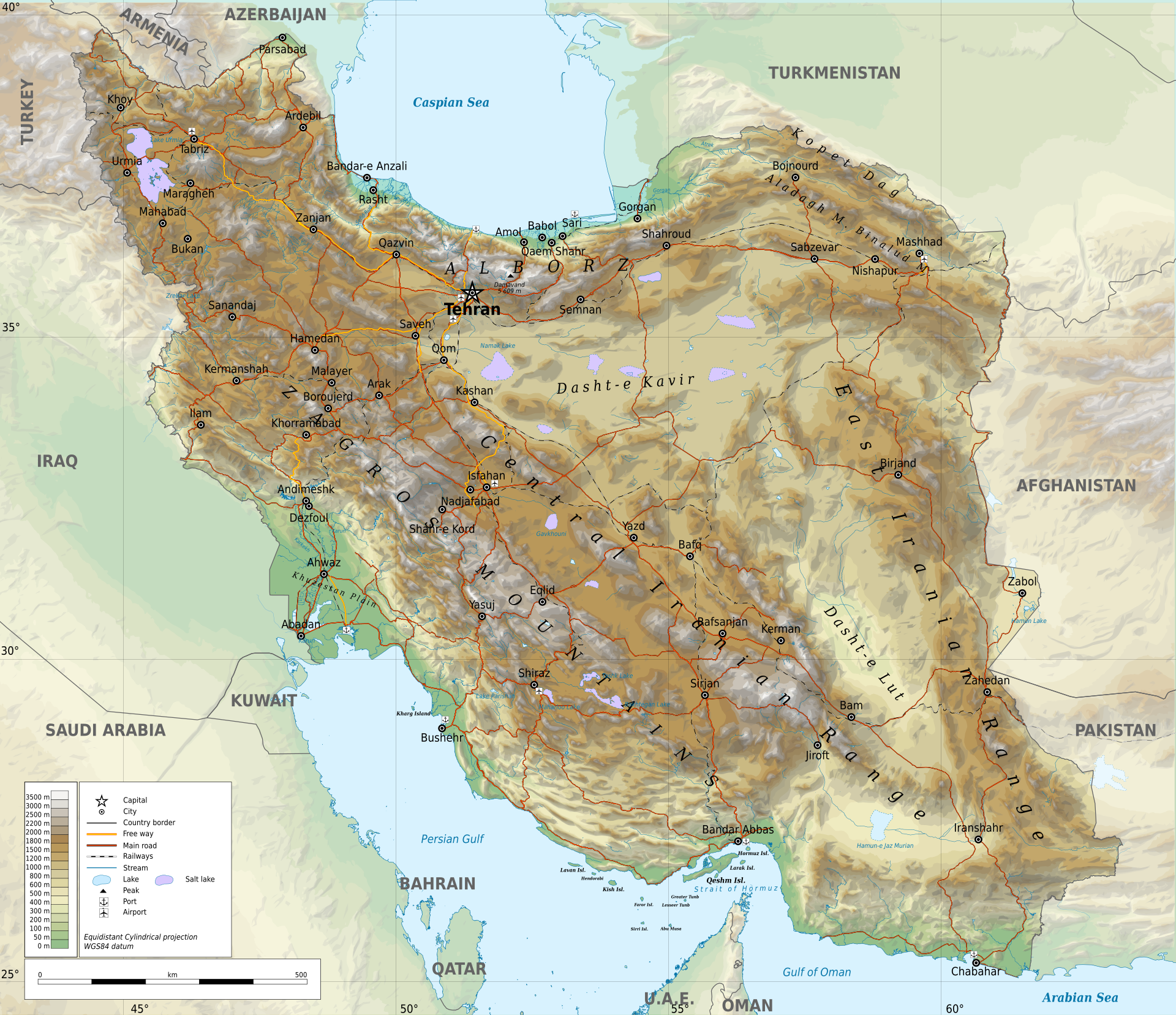
Iran is a West Asian country centred on the Iranian Plateau, between the Caspian Sea and the Persian Gulf–Gulf of Oman coastline. Its mountains, arid interior and position along the Strait of Hormuz give it considerable geographical and strategic importance.
Position matched with OpenStreetMap; the dashed outline shows its mapped extent. Other numbered pins are the day's other places — tap one to open it.
Why in the news
Iran–U.S. negotiations remained stalled over uranium enrichment, with mediators warning of renewed conflict. Foreign Minister Araghchi sought guarantees of Washington’s seriousness about diplomacy and said highly enriched uranium should remain inside Iran. Iran also barred IAEA inspections of its nuclear sites, citing security concerns and the agency’s failure to condemn U.S. and Israeli attacks on those facilities.
Capital
Tehran
Highest point
Mount Damavand
Major river
Karun
Northern water body
Caspian Sea
Southern coastal waters
Persian Gulf and Gulf of Oman
Land neighbours
Seven countries
Location
- Lies in West Asia, east of Iraq and Türkiye and west of Afghanistan and Pakistan.
- Borders Armenia, Azerbaijan and Turkmenistan along its northern side.
- Has a northern coastline on the Caspian Sea and southern coastlines on the Persian Gulf and Gulf of Oman.
- Forms the northern side of the Strait of Hormuz, opposite Oman’s Musandam Peninsula.
Bordering countries
- Iraq
- Türkiye
- Armenia
- Azerbaijan
- Turkmenistan
- Afghanistan
- Pakistan
Key features
- Iranian Plateau
- An extensive upland region containing mountain chains, enclosed basins and arid plains.
- Zagros Mountains
- Run broadly northwest–southeast through western and southwestern Iran; associated with Arabian–Eurasian plate convergence.
- Alborz Mountains
- Extend across northern Iran south of the Caspian Sea and include Mount Damavand.
- Interior deserts
- Dasht-e Kavir and Dasht-e Lut are major desert regions of Iran’s interior.
- Khuzestan Plain
- A lowland region in southwestern Iran adjoining Iraq and the northern Persian Gulf.
- Strait of Hormuz
- Connects the Persian Gulf with the Gulf of Oman and is a major maritime energy chokepoint.
Flora, fauna & ecology
- Climate contrast
- Much of Iran is arid or semi-arid, while the southern Caspian coastal belt is markedly more humid.
- Hyrcanian forests
- Temperate broadleaf forests occupy parts of the southern Caspian coastal belt and northern Alborz slopes.
- Desert wildlife
- Iran supports the surviving wild population of the critically endangered Asiatic cheetah.
History & significance
- Iran was the heartland of ancient Persian empires, including the Achaemenid Empire.
- The 1979 Iranian Revolution led to the establishment of the Islamic Republic.
UPSC angle
- Prelims map work: distinguish Iran’s land neighbours from countries across the Persian Gulf.
- Physical geography: relate the Zagros to plate convergence and contrast the Alborz–Caspian belt with the arid interior.
- Strategic geography: trace the Persian Gulf–Strait of Hormuz–Gulf of Oman maritime route.
- GS II: connect the nuclear dispute with IAEA safeguards, diplomacy and West Asian security.
- GS III: examine how instability around Hormuz can affect India’s energy security and shipping.
Also locate on your map
- Strait of Hormuz
- Musandam Peninsula
- Persian Gulf
- Gulf of Oman
- Caspian Sea
- Zagros Mountains
- Chabahar
- Dasht-e Lut
Test yourself
Q1. Which of the following groups consists entirely of countries sharing a land border with Iran?
Q2. With reference to Iran’s physical geography, consider the following statements: 1. The Alborz Mountains lie south of the Caspian Sea. 2. The Strait of Hormuz connects the Persian Gulf with the Gulf of Oman. 3. The Zagros Mountains lie mainly along Iran’s eastern border. Which of the statements given above are correct?
Sources
- The Hindu: Iran wants diplomacy to end war, says Araghchi as U.S. rejects terms
- The Hindu: Iran says allies China, Russia oppose change in nuclear doctrine
- The Hindu: Iran-U.S. negotiations stalled over uranium enrichment dispute, mediators warn of renewed conflict, says reports
Background maps and imagery © Esri and partners (English labels); place positions checked with OpenStreetMap (ODbL). Boundaries are for study reference only. Prepared by Pragnya IAS Academy for exam revision.