
ISRO’s NVS-03 Launch Plan: NavIC Architecture and India’s Navigation Autonomy
Revise the static topic: UPSC Science & Technology notes
In short: ISRO has scheduled the launch of NVS-03 on October 30 from Sriharikota to support continuity of India’s regional navigation services. Carrying an indigenous atomic clock alongside other atomic clocks, the satellite is important for NavIC’s renewal and India’s autonomous positioning and timing capabilities; operational success will require orbit raising and commissioning after launch.
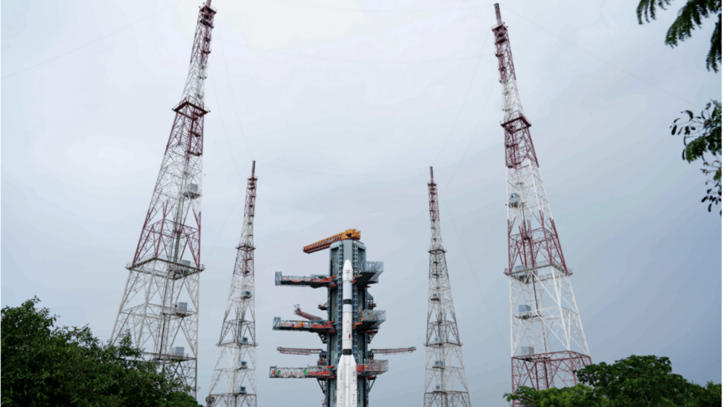
Reference image from coverage of ISRO’s navigation satellite programme, not the planned NVS-03 launch. NVS-03 is intended to support continuity of NavIC’s regional positioning and timing services.
Image: Indian Express
Why in news
NVS-03 is scheduled to be launched aboard GSLV-F18 following corrective measures recommended after the NVS-02 orbit-raising failure. The supplied report announces a planned launch, not a completed mission.
Third
Satellite in the next-generation navigation series
Around 2,250 kg
NVS-03 mass
1,500 km
Coverage extension beyond India
Background
Navigation with Indian Constellation, or NavIC, is India’s independent regional satellite navigation system, developed by ISRO and originally known as the Indian Regional Navigation Satellite System. Its architecture combines geostationary and inclined geosynchronous satellites with ground-based monitoring and control facilities and compatible user receivers. Unlike a global constellation such as GPS, NavIC is designed primarily for India and its surrounding region. It provides a Standard Positioning Service for civilian users and a Restricted Service for authorised users.
What is planned for NVS-03?
NVS-03 is intended to sustain navigation services as part of the next-generation satellite series succeeding the original IRNSS satellites. ISRO plans to place it in a Geosynchronous Transfer Orbit using GSLV-F18 from the second launchpad at Sriharikota.
The satellite will carry an indigenous atomic clock along with other atomic clocks. Its intended service footprint covers the Indian landmass and extends up to 1,500 km beyond India.
Insertion into a transfer orbit is an intermediate milestone. The spacecraft must subsequently reach its intended operational orbit, undergo payload checks and be integrated into the navigation service.
- Constellation renewal supports continuity as existing satellites age or develop subsystem limitations.
- An indigenous clock strengthens domestic capability in a critical navigation payload component.
- The announcement does not establish that launch, orbit raising or service commissioning has succeeded.
Infographic
Constellation renewal
Next-generation satellites support continuity of NavIC services.
Precision timing
Indigenous atomic-clock capability supports accurate ranging.
Mission assurance
Launch must be followed by orbit raising and commissioning.
User ecosystem
Compatible receivers convert space capability into practical services.
Strategic resilience
Independent regional services work best with redundancy and interoperability.
AI-assisted infographic by Pragnya IAS Academy, based on the cited sources.
NavIC architecture: space, ground and user segments
The space segment combines geostationary satellites, which appear fixed over the equator, with inclined geosynchronous satellites, whose apparent positions vary over a sidereal day. This architecture supports persistent regional coverage rather than worldwide service.
The ground segment tracks satellites, monitors clock and orbit behaviour, and uploads navigation information and corrections. The user segment consists of compatible receivers that process signals from multiple satellites to estimate position and receiver-clock error.
Satellite navigation is fundamentally a timing-based ranging process. Receivers use the travel time of broadcast signals to estimate distance, making accurate clocks and reliable orbital information indispensable.
- A navigation service is an integrated system, not merely a collection of satellites.
- Navigation reception does not ordinarily require the receiver to transmit its location to the satellite.
- Coverage does not automatically guarantee reliable reception inside buildings, tunnels or heavily obstructed areas.
Why next-generation satellites and indigenous clocks matter
Next-generation satellites help replenish the constellation and maintain service continuity. However, a successful replenishment programme also depends on spacecraft reliability, ground control and receiver availability.
Atomic clocks provide highly stable time references. Because distance estimates depend on signal travel time, timing errors can translate into positioning errors. Ground monitoring and correction remain necessary even when satellites carry atomic clocks.
Indigenous clock capability reduces dependence on external suppliers for a strategically important subsystem and supports domestic expertise in precision timing. It should not be equated with complete self-reliance across the entire satellite navigation ecosystem.
- The immediate objective is continuity of regional navigation services.
- Clock indigenisation supports technological autonomy and supply-chain resilience.
- Actual user benefits depend on successful commissioning and compatible receiving equipment.
NVS-02 lessons: launch success is not service success
The reported NVS-02 failure occurred during orbit raising after its January 2025 launch aboard GSLV-F15. The analysis found that a drive signal did not reach the pyro valve in the engine’s oxidiser line, preventing the intended transition from the elliptical transfer orbit towards the operational orbit.
The source states that NVS-03 is planned after corrective measures suggested by the Apex Committee that examined the NVS-02 shortcomings. It does not provide enough detail to assess the individual modifications or their effectiveness.
The key engineering lesson is end-to-end mission assurance: launch-vehicle performance, spacecraft propulsion, command pathways, navigation payloads and ground operations must all work reliably.
- Orbit insertion and post-separation spacecraft operations are distinct mission stages.
- A propulsion-system command-path failure can prevent service entry even after launch.
- Corrective measures must be validated through integrated testing rather than inferred from launch readiness alone.
| Component or orbit | Function | Exam distinction |
|---|---|---|
| Geostationary orbit | Supports persistent visibility over a region | A circular equatorial geosynchronous orbit whose satellite appears fixed from Earth |
| Inclined geosynchronous orbit | Supports regional satellite geometry and coverage | Its orbital period matches Earth’s rotation, but the satellite does not appear stationary |
| Geosynchronous Transfer Orbit | Provides an intermediate trajectory before orbit raising | Transfer-orbit insertion is not equivalent to operational deployment |
| Ground segment | Monitors orbits and clocks and updates navigation information | Essential for sustaining service accuracy and reliability |
| User segment | Processes navigation broadcasts to estimate position and time | Requires compatible receivers and adequate signal reception |
- 1. GSLV-F18 places NVS-03 into a Geosynchronous Transfer Orbit.
- 2. Spacecraft propulsion raises and adjusts the orbit towards the intended operational configuration.
- 3. Ground teams check spacecraft systems, atomic clocks and navigation payload performance.
- 4. Monitoring facilities validate orbit and clock information and navigation broadcasts.
- 5. The satellite is commissioned into service for compatible user receivers.
January 2025
NVS-02 was launched aboard GSLV-F15 but encountered a failure during subsequent orbit-raising operations.
Following the NVS-02 failure
An Apex Committee analysed the shortcomings and recommended corrective measures.
October 30, scheduled
ISRO plans to launch NVS-03 aboard GSLV-F18 from Sriharikota into a Geosynchronous Transfer Orbit.
Significance, challenges & way forward
Significance
- An independently controlled regional navigation system reduces exclusive reliance on foreign positioning and timing services.
- Reliable positioning supports transport, fisheries, surveying and disaster-response operations.
- Precise timing can support synchronisation in telecommunications, power systems and financial infrastructure when suitable equipment is deployed.
- Indigenous atomic-clock development strengthens a critical space-technology capability.
- Constellation replenishment helps preserve the continuity of public and strategic navigation services.
Challenges
- Successful launch must be followed by reliable orbit raising, payload validation and service commissioning.
- Continuity depends on the health of the wider constellation and ground infrastructure, not only NVS-03.
- Atomic-clock stability requires sustained monitoring, correction and dependable payload engineering.
- Limited receiver compatibility or inadequate integration can prevent satellite capability from translating into widespread use.
- Navigation signals remain vulnerable to obstruction, interference, jamming and spoofing; national ownership does not eliminate these risks.
- NavIC’s regional design cannot by itself provide worldwide positioning coverage.
Way forward
- Strengthen integrated testing of propulsion, electrical command pathways and mission-critical interfaces using lessons from NVS-02.
- Plan timely constellation replenishment and suitable redundancy across satellites and ground systems.
- Support indigenous clock development alongside rigorous qualification and long-term performance monitoring.
- Expand affordable NavIC-compatible receivers and validate applications under real operating conditions.
- Use multi-constellation reception and complementary terrestrial or inertial systems where resilience is essential.
- Communicate launch, orbit-raising, commissioning and service-health milestones separately to enable accurate public assessment.
Key terms
- NavIC
- Navigation with Indian Constellation, India’s independent regional satellite navigation system.
- Positioning, Navigation and Timing
- Services that determine location, support movement and provide precise time references.
- Atomic clock
- A clock that uses a stable atomic transition as its frequency reference.
- Geosynchronous orbit
- An Earth orbit with a period equal to Earth’s sidereal rotation period.
- Geostationary orbit
- A circular equatorial geosynchronous orbit in which a satellite appears stationary relative to Earth.
- Geosynchronous Transfer Orbit
- An elliptical intermediate orbit used to transfer a spacecraft towards its intended geosynchronous orbit.
- Pyro valve
- A valve actuated by a pyrotechnic mechanism, used to control fluid flow in spacecraft systems.
- Spoofing
- Transmission of deceptive navigation signals intended to mislead a receiver about position or time.
Link with static syllabus
Prelims practice MCQs
Q1. With reference to NavIC, consider the following statements: 1. It is designed primarily as a regional satellite navigation system. 2. Its architecture includes both space-based and ground-based components. 3. Every user receiver must transmit its location to a navigation satellite to obtain a position estimate. Which of the statements given above are correct?
Q2. Which of the following best describes the significance of placing NVS-03 in a Geosynchronous Transfer Orbit?
Q3. Consider the following statements about satellite orbits: 1. A geostationary orbit is a special case of a geosynchronous orbit. 2. Every geosynchronous satellite appears stationary to an observer on Earth. Which of the statements given above is/are correct?
Q4. Why are atomic clocks important in satellite navigation?
Mains practice questions
GS 3 · 15 marks · 250 words
Explain how NavIC contributes to India’s strategic autonomy. Discuss the technological and operational requirements for translating constellation renewal into dependable positioning and timing services.
Frequently asked questions
Has NVS-03 already been successfully launched?
The supplied report announces a launch scheduled for October 30. It does not confirm launch completion, successful orbit raising or operational commissioning.
Is NavIC a global navigation system?
No. NavIC is designed primarily for India and the surrounding region, with its primary service area extending up to 1,500 km beyond India.
Why is the indigenous atomic clock significant?
Precise timing is essential for calculating distances from navigation signals. An indigenous clock reduces dependence on external suppliers for a critical component, though other systems and ground corrections remain necessary.
What went wrong with NVS-02?
According to the source, a drive signal did not reach the pyro valve in the engine’s oxidiser line during orbit raising. The resulting failure prevented the intended orbital transition; it should not be described simply as a launch-vehicle failure.
Sources
- Indian Express: ISRO to launch navigation satellite NVS-03 on Friday
Analysis prepared by the Pragnya IAS Academy current-affairs desk with AI assistance from the cited reports. Verify figures with the original sources.
Turn current affairs into marks
Join Pragnya IAS Academy's mentorship for daily answer-writing evaluation on stories like this — classroom programmes from a trusted name in IAS coaching in Hyderabad.