
WINDS Rollout Delays: Weather Data Gaps, Crop Advisories and Insurance Risks
Revise the static topic: UPSC Agriculture notes · UPSC Economy notes
In short: The Agriculture Ministry’s Weather Information Network and Data System (WINDS) is at least a year behind schedule, with The Hindu reporting that over 96% of planned sensors remain uninstalled in the rollout it examined. Land shortages, rejected sites and disputed rooftop-installation restrictions are delaying infrastructure intended to strengthen hyper-local weather information and crop-insurance assessment.
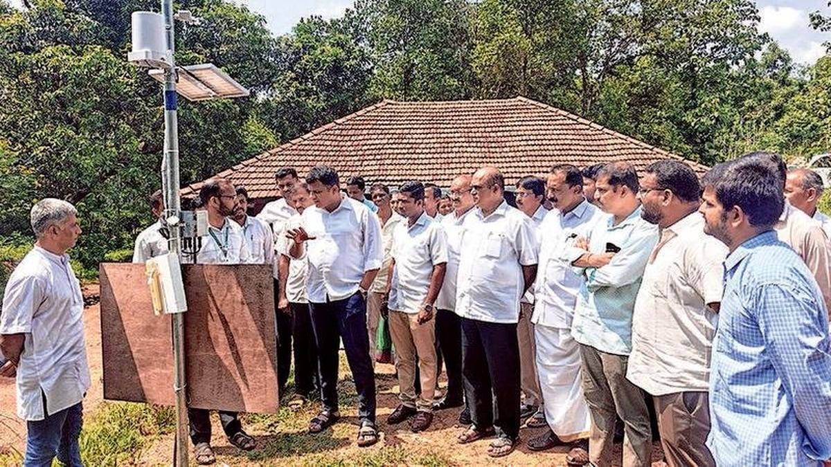
Reference image accompanying reporting on WINDS, whose weather-sensor rollout is delayed by land shortages, rejected sites and disputed rooftop-installation restrictions.
Image: The Hindu
Why in news
The Hindu has reported very low installation progress under WINDS and a dispute between implementing companies and technical authorities over siting requirements. Private partners allege retrospective restrictions on rooftop installations, while the India Meteorological Department (IMD) maintains that standardised ground-based siting is essential for reliable observations.
Over 96%
Planned sensors reportedly uninstalled
1,197
AWS target for examined rollout
49,313
ARG target for examined rollout
113
AWSs delivered in reported update
1,730
ARGs delivered in reported update
10%
General rooftop ARG ceiling in amendment
Background
Agriculture depends not only on seasonal rainfall totals but also on rainfall distribution, temperature, humidity and wind during different crop stages. Surface observations complement satellites, radar and numerical weather models, while agrometeorological advisories translate weather information into farm decisions. WINDS is run by the Ministry of Agriculture and Farmers Welfare and executed through the Mahalanobis National Crop Forecast Centre (MNCFC), with States implementing the sensor network through private partners. Its principal stated purpose is to supply hyper-local weather data that can aid insurance estimates and payouts under the Pradhan Mantri Fasal Bima Yojana (PMFBY). IMD is a technical partner, not the administering agency.
What is delayed, and where is the bottleneck?
The report documents targets assigned collectively to three private partners: 1,197 automatic weather stations (AWSs) and 49,313 automatic rain gauges (ARGs). Its latest confirmed status update, dated September 9, records delivery of only 113 AWSs and 1,730 ARGs. These figures describe the rollout examined by the newspaper and should not be treated as a count of all weather instruments in India.
Site availability and approval, rather than hardware alone, are the central constraints. The documents cited by the newspaper identify extensive site rejection, duplicate locations, pending clearances and sites not yet shared by States with implementing companies.
- Uttar Pradesh had 16,478 rejected sites out of 27,644 proposed locations.
- Odisha had 5,666 rejected sites out of 7,720 locations.
- Kerala had 524 rejected sites out of 946 locations.
- A plot is useful only if it meets meteorological exposure requirements and permits installation, access and maintenance.
Infographic
Suitable sites
Verified land, proper exposure and clear permissions.
Scientific standards
Consistent siting, calibration and documented exceptions.
Coordinated delivery
Clear responsibilities across States, MNCFC, IMD and partners.
Reliable data
Continuity, quality checks and complete station metadata.
Farmer outcomes
Actionable advisories and stronger insurance assessment.
AI-assisted infographic by Pragnya IAS Academy, based on the cited sources.
Ground versus rooftop: a standards and contract dispute
The September 1, 2023 manual prescribed level ground covered with short grass or natural earth for ARGs, ideally using a 4 × 3 metre plot. It also permitted installation on a single-storey building where suitable siting requirements could not be met or in flood-prone areas, without specifying a numerical rooftop ceiling.
The December 3, 2025 amendment introduced a general rooftop ceiling of 10%, supported by a State justification that suitable ground space is unavailable. In flood- or landslide-prone regions, a 15% ceiling applies with prior State recommendation and WINDS Committee approval. Implementing partners allege that these restrictions affected tenders and work orders already issued; the report does not establish a legal finding of retrospective contractual breach.
IMD’s stated concern is observation quality and comparability. Height, surrounding obstacles and exposure can affect measurements. Ground-based siting means locating instruments within a suitable surface-observation site and mounting them at prescribed heights, not placing every sensor directly on the soil.
- Scientific standards should be explicit before procurement and site mobilisation.
- Exceptional rooftop installations require documented justification rather than unrestricted substitution.
- Contract-transition questions and technical-compliance questions should be resolved separately.
Why local observation gaps matter for farmers
Rainfall and other weather conditions can vary across nearby locations. Sparse observations can leave advisories dependent on measurements that do not adequately represent a farmer’s field. This can weaken decisions on sowing, irrigation, fertiliser application, spraying and harvesting, especially when the timing of a weather event matters more than its seasonal total.
Reliable local data can also support agricultural risk assessment, insurance estimates and scrutiny of weather-related losses. However, installing a weather sensor does not itself determine every PMFBY payout: the scheme’s assessment procedures and applicable coverage provisions remain relevant. PMFBY should not be equated with a purely weather-index-based insurance product.
Network expansion must therefore be assessed through usable information, not equipment counts alone. An installed station that produces interrupted, poorly calibrated or unrepresentative observations may provide limited value for either advisories or insurance.
- Missing observations can obscure local rainfall deficits or intense rainfall episodes.
- Biased measurements can create false confidence in advice and risk estimates.
- Weather information must be combined with crop stage, soil conditions and agronomic expertise.
- Forecasts must reach farmers in an understandable and actionable form.
The governance challenge: coverage with credible data
WINDS requires coordination among the Agriculture Ministry, MNCFC, IMD, State authorities, local institutions and private operators. The rollout illustrates how infrastructure procurement can stall when land identification, technical clearance and contractual obligations are not aligned.
The appropriate response is neither to dilute standards for rapid completion nor to leave approvals indefinitely unresolved. A coordinated system should identify compliant sites before installation, provide a transparent route for exceptional cases and monitor operational data quality throughout the asset’s life.
- MNCFC should coordinate implementation responsibilities, escalation and progress review.
- IMD’s technical requirements should be translated into a clear site-screening checklist.
- States should identify available public or community sites, subject to technical suitability and lawful permissions.
- Private partners should maintain installation records, calibration, connectivity and repair arrangements.
| Feature | Automatic rain gauge | Automatic weather station |
|---|---|---|
| Primary observations | Rainfall; some WINDS units also carry a temperature sensor | Rainfall, air temperature, relative humidity, wind speed and wind direction |
| Agricultural relevance | Local rainfall monitoring for farm decisions and risk assessment | Multi-variable weather information for advisories and risk assessment |
| Target documented for the examined rollout | 49,313 | 1,197 |
| Delivery in the September 9 update | 1,730 | 113 |
| Quality requirement | Suitable exposure, standardised siting and maintenance | Variable-specific exposure, prescribed sensor heights, calibration and maintenance |
- 1. Identify and technically screen representative sites.
- 2. Secure permissions and install instruments to prescribed standards.
- 3. Calibrate, maintain and transmit observations with site metadata.
- 4. Apply quality checks and integrate observations with wider weather information.
- 5. Generate crop-specific advisories and support applicable insurance assessments.
- 6. Deliver actionable information and use feedback to improve service quality.
September 1, 2023
WINDS manual prescribed ground siting for ARGs while allowing specified rooftop exceptions without a numerical ceiling.
December 3, 2025
The amendment introduced a general 10% rooftop ARG ceiling and a 15% ceiling for flood- or landslide-prone regions, with specified justification and approval requirements.
Significance, challenges & way forward
Significance
- Representative local observations can improve the relevance of weather-informed agricultural decisions.
- Reliable measurements strengthen the evidentiary base for agricultural risk assessment and insurance-related analysis.
- Standardised siting makes observations more comparable across locations and over time.
- The project demonstrates that digital agriculture depends on physical infrastructure, maintenance and institutional coordination.
Challenges
- Suitable land must satisfy both administrative availability and meteorological exposure requirements.
- Changes affecting existing procurement can create uncertainty unless transition arrangements are explicit.
- Duplicate sites and unresolved clearances delay installation and may distort planned coverage.
- Poor calibration, outages or missing metadata can undermine the value of an apparently completed network.
- Farm-level weather variability cannot be eliminated merely by installing instruments at administrative locations.
- Better observations do not automatically produce timely advisories or settle insurance claims.
Way forward
- Create a jointly verified, geotagged inventory of technically suitable sites before further installation commitments.
- Publish a common siting checklist and record the specific reason for every site rejection.
- Resolve existing contract disputes through documented review while preserving essential scientific standards.
- Use rooftop exceptions only through the prescribed justification and approval process, with exposure and height recorded in metadata.
- Monitor uptime, calibration, data completeness and maintenance alongside installation progress.
- Prioritise underserved and agriculturally vulnerable locations within the approved network design.
- Connect validated observations to crop-specific advisories, accessible communication channels and auditable insurance workflows.
Key terms
- WINDS
- Weather Information Network and Data System, an Agriculture Ministry programme for a nationwide hyper-local weather-sensor network.
- Automatic rain gauge
- An instrument that automatically measures and records rainfall.
- Automatic weather station
- An automated installation that records multiple weather variables, including rainfall, temperature, humidity and wind.
- Agrometeorological advisory
- Farm guidance that combines weather information with crop and agronomic knowledge.
- Siting standards
- Requirements governing instrument location, exposure and mounting to obtain representative, comparable observations.
- Basis risk
- In index-based insurance, the risk that an index-linked payout does not match the policyholder’s actual loss.
- Station metadata
- Information on a station’s location, instrument heights, surroundings and changes needed to interpret its measurements.
Link with static syllabus
Prelims practice MCQs
Q1. With reference to WINDS, consider the following statements: 1. It is run by the Ministry of Agriculture and Farmers Welfare. 2. The Mahalanobis National Crop Forecast Centre is its executing agency. 3. IMD is the administering agency responsible for the project’s implementation. Which of the statements given above are correct?
Q2. Consider the following statements about meteorological observations: 1. An automatic weather station can measure humidity and wind in addition to rainfall. 2. Rooftop and ground-based observations can always be treated as directly interchangeable without examining exposure. 3. Instrument calibration and maintenance remain necessary after installation. Which of the statements given above are correct?
Q3. Which of the following best describes basis risk in weather-index insurance?
Q4. With reference to the WINDS siting provisions reported by The Hindu, consider the following statements: 1. The 2023 manual allowed specified rooftop exceptions without a numerical ceiling. 2. The 2025 amendment introduced a general 10% rooftop ARG ceiling. 3. The amendment allowed unrestricted rooftop installation in flood-prone regions. Which of the statements given above are correct?
Mains practice questions
GS 3 · 15 marks · 250 words
Gaps in local weather observations are both an infrastructure deficit and a governance challenge for Indian agriculture. Discuss with reference to crop advisories, agricultural insurance and the implementation of WINDS.
Frequently asked questions
What is WINDS intended to do?
WINDS aims to build a nationwide network supplying hyper-local weather observations. Its principal stated purpose is to aid insurance estimates and payouts under PMFBY.
Why are ground-based installations preferred?
Standardised ground-based sites help control differences in exposure, surroundings and instrument height. Rooftop installations can introduce measurement differences and therefore require carefully governed exceptions.
Does the rollout delay mean India has no local weather observations?
No. The report concerns delayed additions under the examined WINDS rollout, not the absence of India’s existing weather-observation systems.
Will more weather stations automatically improve crop-insurance settlements?
They can strengthen the evidence available for assessment, provided their observations are reliable and representative. Settlement outcomes also depend on applicable insurance provisions, assessment procedures and administrative processing.
Sources
Analysis prepared by the Pragnya IAS Academy current-affairs desk with AI assistance from the cited reports. Verify figures with the original sources.
Turn current affairs into marks
Join Pragnya IAS Academy's mentorship for daily answer-writing evaluation on stories like this — classroom programmes from a trusted name in IAS coaching in Hyderabad.