
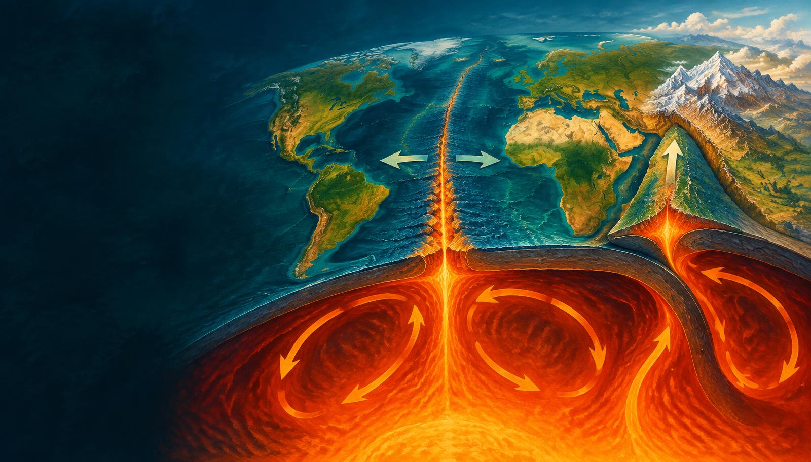
InfoGraphix by Pragnya · Geography · Chapter 3
Distribution of Oceans and Continents
Follow the evidence from continental drift to seafloor spreading and plate tectonics. Apply the framework to India’s journey, boundary hazards and isostatic adjustment.
- 18 visual topics
- 54 practice MCQs
- 54 flip cards
From reconstruction to a dynamic Earth
Topics 1–6
Evidence for mobile continents
Reconstruct Pangaea using rocks, fossils and glacial evidence, then discover mantle circulation and ocean-floor renewal.
Topics 7–12
A global plate system
Test spreading with magnetic bands, map plates and compare divergent, subduction and collision margins.
Topics 13–18
India and vertical balance
Study transforms, India’s journey and margins, then explain isostatic roots, loading and rebound.
Milestones and applications
Scroll the ribbon and tap any milestone to open its infographic.
1912
Continental drift
Wegener reconstructs formerly connected continents.
Open topic →1920s–1930s
A thermal mechanism
Holmes develops mantle-convection ideas.
Open topic →Mid-20th century
Seabed mapping
Bathymetry and seismicity reveal ridges, trenches and slabs.
Open topic →Early 1960s
Seafloor spreading
Hess and Dietz connect ocean-floor creation and recycling.
Open topic →1963
Magnetic test
Vine–Matthews interpretation connects reversals with spreading.
Open topic →Late 1960s
Plate framework
Relative lithospheric motion unifies major tectonic processes.
Open topic →≈66 Ma
Deccan eruptions
India’s path is associated with Réunion plume volcanism.
Open topic →≈50–60 Ma
Continental collision
India–Eurasia convergence initiates the Himalayan–Tibetan collision system.
Open topic →Today
Continuing adjustment
Plate movement, loading and unloading reshape Earth’s surface.
Open topic →
Topic index
Follow the numbers in order, or jump to what you need.
0 of 18 revised on this device
- 11912
Continental Drift: The Original Proposal
Wegener, Pangaea and a missing engine
Wegener reconstructed continents as parts of an earlier connected landmass. His evidence challenged fixed continents, but his proposed driving forces could not explain their motion.
Open infographic - 2Evidence
Geological Fit: Margins, Rocks and Placers
Test the join with independent evidence
Continental-margin fit becomes more persuasive when geological structures continue across the reconstructed join. Rock belts and sediment provenance are stronger checks than coastline resemblance alone.
Open infographic - 3Evidence
Fossils and Glacial Evidence
Mesosaurus, Glossopteris and tillite
Fossils and ancient glacial deposits connect now-separated Gondwana fragments. Their distributions are best interpreted together with age control and reconstructed palaeolatitudes.
Open infographic - 41920s–1930s onward
Mantle Convection and Plate-driving Forces
Holmes, slab pull and ridge push
Holmes supplied a plausible thermal mechanism for large-scale movement. Modern explanations include mantle circulation, slab pull and gravitational sliding from ridges rather than a single conveyor-belt model.
Open infographic - 5Post-war exploration
Mapping the Ocean Floor
Echo sounding reveals a structured seabed
Ocean-floor mapping revealed ridges, trenches and broad plains rather than a featureless basin. Bathymetry, sampling and earthquake locations together transformed ideas about ocean-basin evolution.
Open infographic - 6Early 1960s
Seafloor Spreading: Creation and Recycling
Hess connects ridges with trenches
Seafloor spreading creates oceanic crust at ridges and carries it away as plates separate. Subduction returns oceanic lithosphere to the mantle, explaining the scarcity of very old ocean floor.
Open infographic - 71963 onward
Magnetic Stripes and Spreading Rates
A magnetic clock on moving basalt
Cooling basalt records the polarity of Earth’s magnetic field. Matching reversal sequences on opposite ridge flanks, combined with radiometric ages, provide a powerful test of seafloor spreading.
Open infographic - 8Late 1960s
Plate Tectonics: The Unifying Framework
Rigid lithosphere over weaker asthenosphere
Plate tectonics treats Earth’s outer shell as moving lithospheric plates. It links continental displacement, ocean-floor creation, subduction and boundary deformation within one testable framework.
Open infographic - 9World map
Major and Minor Plates: Map Practice
Learn location before memorising lists
A plate list is a simplified map of a more complex deforming shell. Learn the large plates and locate the smaller plates around Central America, the western Pacific and the Indian Ocean.
Open infographic - 10Boundary processes
Divergent Boundaries: Rifts to Ocean Basins
Extension creates new oceanic lithosphere
Divergence stretches lithosphere and permits mantle upwelling. Continental rifting may evolve into a narrow sea and eventually an ocean basin, although many rifts fail before reaching that stage.
Open infographic - 11Boundary processes
Subduction: Trenches, Arcs and Volcanic Belts
Ocean–ocean versus ocean–continent
Subduction transfers oceanic lithosphere into the mantle and generates characteristic trench–arc systems. Whether the overriding plate is oceanic or continental helps determine the resulting landforms.
Open infographic - 12Boundary processes
Continental Collision and Mountain Building
Crustal shortening builds thick roots
Continental collision follows the consumption of intervening oceanic lithosphere. Buoyant continental crust shortens, thickens and underthrusts, building high ranges and plateaux such as the Himalaya and Tibet.
Open infographic - 13Boundary processes
Transform Boundaries and Tectonic Hazards
Conservative does not mean harmless
Transform boundaries accommodate lateral relative motion without net creation or destruction of lithosphere. Their shallow earthquakes can be highly destructive, especially where active faults cross densely settled areas.
Open infographic - 14Mesozoic–present
The Indian Plate: Gondwana to the Himalaya
Breakup, Deccan volcanism and collision
India’s northward journey involved several stages of Gondwana breakup, rapid oceanic motion and eventual collision with Eurasia. Deccan volcanism and the Himalayan belt mark different parts of that history.
Open infographic - 15India and Indian Ocean
Indian Plate Margins and Present-day Questions
Read a boundary map, not a rectangle
India’s plate margins combine collision, subduction, strike-slip deformation and spreading. Simplified textbook outlines must be distinguished from modern maps that separate Indian, Australian, Arabian and Sunda-related motions.
Open infographic - 16Vertical balance
Isostasy: Airy and Pratt Models
Equal pressure at a compensation level
Isostasy explains broad vertical balance between the lithosphere and denser underlying mantle. Airy and Pratt models obtain comparable pressure at depth by changing column thickness or column density respectively.
Open infographic - 17Processes and applications
Rebound, Erosion and Applied Tectonics
Changing loads trigger vertical adjustment
Changing surface loads cause isostatic adjustment over time. Glacial unloading, erosion and sediment accumulation connect deep Earth mechanics with coastlines, river basins and mountain evolution.
Open infographic - 18Revision
Chapter Quick Revision
Numbers, contrasts and an answer framework
Revise the chapter as an evidence-to-mechanism sequence, then apply it to India and vertical crustal balance. Keep dates approximate where debated and distinguish horizontal rates from uplift.
Open infographic
Full reading notes in the Study Library
- Continental drift →
- Glacial landforms →
- Mantle →
- Plate tectonics →
- Ocean floor →
- Earthquakes →
- Sea-floor spreading →
- Earth's interior →
- Faulting →
- Volcanoes →
- Islands →
- Folding →
- Mountains →
- Himalayas →
- Peninsular Plateau →
- Marine resources →
- Crust →
- Coastal Plains →